Our Training Airfields
| Site: | Open Flight School |
| Course: | General Principles (DCS) |
| Book: | Our Training Airfields |
| Printed by: | Guest user |
| Date: | Sunday, 22 March 2026, 11:42 AM |
1. Caucasus (free to play Map)
We have decided to use the Caucasus map as the standard training map for all DCS modules.
The rationale is relatively simple. This card is included free of charge in DCS-World. We would like to enable every student to participate in our courses without having to buy an additional card.
Of course, it would be more atmospheric to do the course with a Focke Wulf 190 in the Normandy map or with the A-10C in Nevada. But if someone has just enough money to buy the module, he should be able to learn how to fly it. We will certainly try to offer missions on the appropriate maps later on. But this is currently additional effort that we can not (yet) afford.
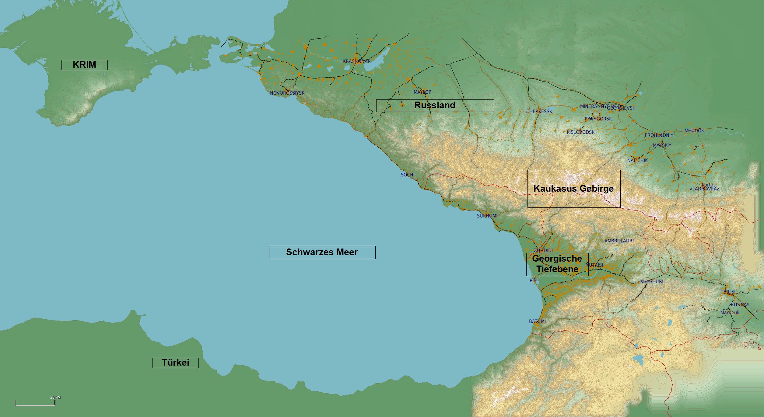
Caucasus Map General Overview
1.1. Krymsk URKW
Height (ELEV / QNH):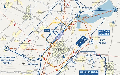
20m/66ft
Runway:
Concrete, 2600m x 60m, (8530ft x197ft)
Controlled Airspace
Class D:GND (0) bis 3500ft
Overflight:
>3500ft
Special Features:
Restricted zone UR-R152 in the southeast
Transmission mast in the north
According to the Visual Operation Chart, we find two areas for possible aerodrome circles (marked in dashed yellow) within the SFO at Krymsk aerodrome. A large aerodrome circuit to the south-east and a smaller one to the north-west. In addition to the actual size of the specified area, the different altitude limitations must also be taken into account.
.
|
(Click to enlarge) |
Incoming traffic (Approach):
from the south and east:
- via Entry Point East to runway 22
from North and West:
- via Entry Point North on runway 22
Departing traffic (Departure):
- Five Exit Points as shown on the map, depending on the direction of take-off and the departure course.
- For departures via Exit Abinsk, follow course and course of exclusion zone boundary exactly.
Aerodrome Circuit:
- as required and cleared in the designated area
|
|
(Click to enlarge) |
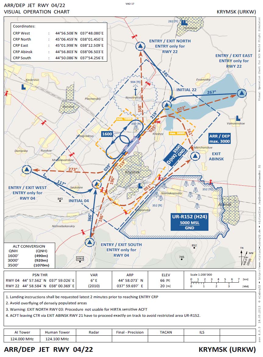
Due to the ongoing shortage of equipment in Russia, the taxiways are not signposted. This would be unthinkable for civil aviation, but this is a military airfield and different rules apply here. |
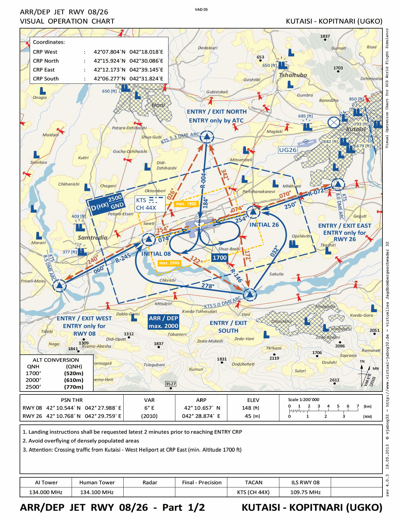
1.2. Kutaisi-Kopitnari UGKO
Height (ELEV / QNH): 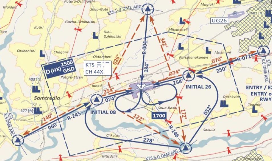
45m/148ft
Runway:
Concrete, 2500m x 60m, (8200ft x 197ft).
Controlled Airspace:
CLASS D - Ground (0) to 2500ft
Overflight:
>2500ft
Special features:
According to the Visual Operation Charts, we find specified approach paths within the OFS at Kutaisi-Kopitnari airfield.
In the immediate vicinity (7.5 Nm, 50°) is an old airfield (UG26), which is used not only for civil aviation, but also by the police and military, especially for helicopter squadrons. Here, the Echo approach route crosses the East approach route from Kopitnari. It is therefore mandatory to maintain the minimum altitude when approaching via East.
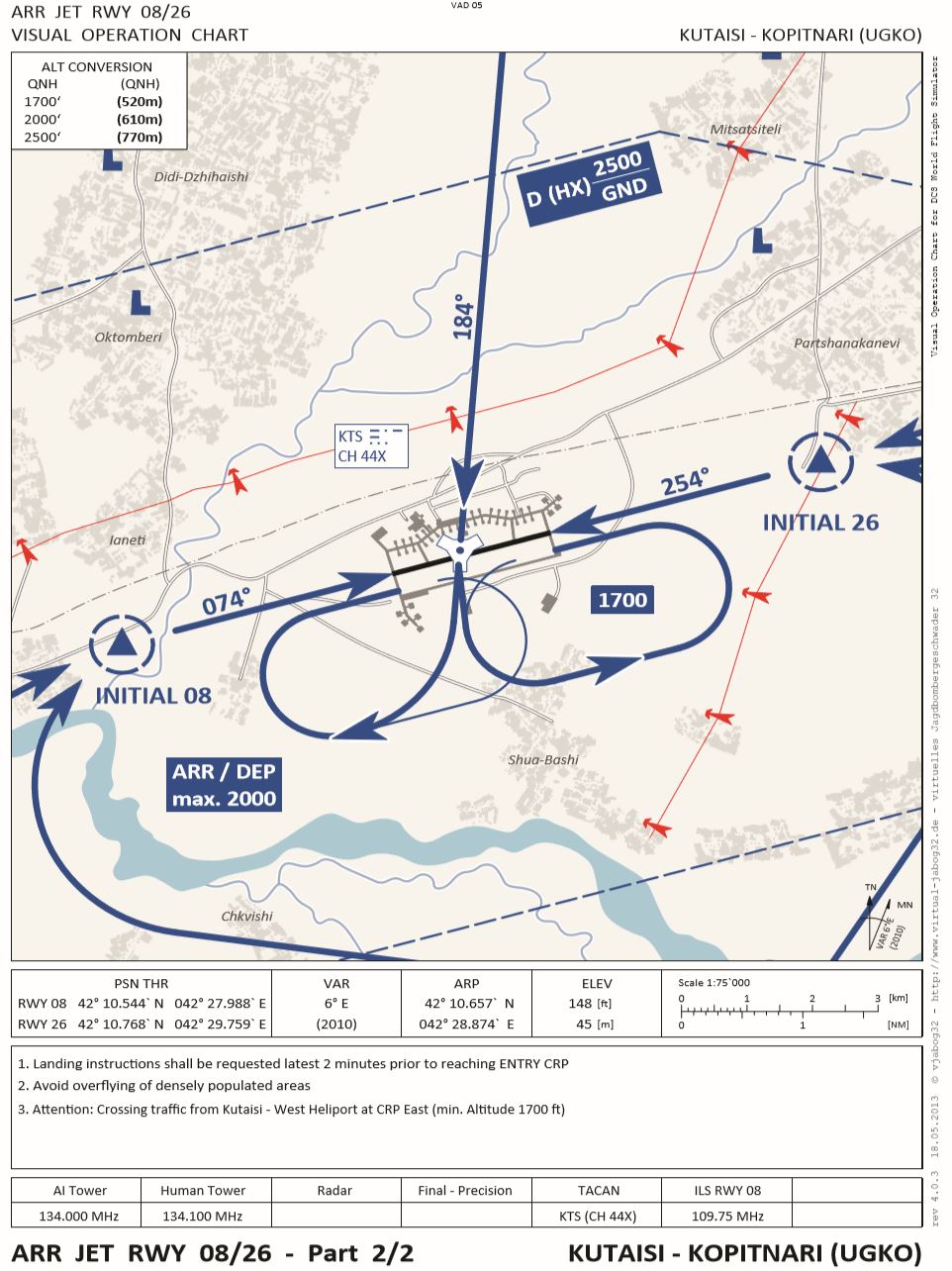
Two designated areas for aerodrome circuits with different altitude limits.
|
|
Incoming traffic (Approach) from all directions: - via Entry South to runway 08 / 26 - via Entry Point East to runway 26 (minimum altitude 1700) TACAN approach: - via Entry North R-004 Holding Pattern: - as required and cleared in the designated area Departure traffic: - Four Exit Points as shown on the chart depending on take-off direction and departure course. - For departures via Exit East, observe minimum altitude 1700.
- North with altitude restriction 1500ft - South with altitude restriction like airspace D 2500ft |
|
(click to enlarge) |
|
|
(click to enlarge) Aerodrome charts as pdf: Download |
schöner kurzer und direkter Anflug auch für Jets via TACAN |
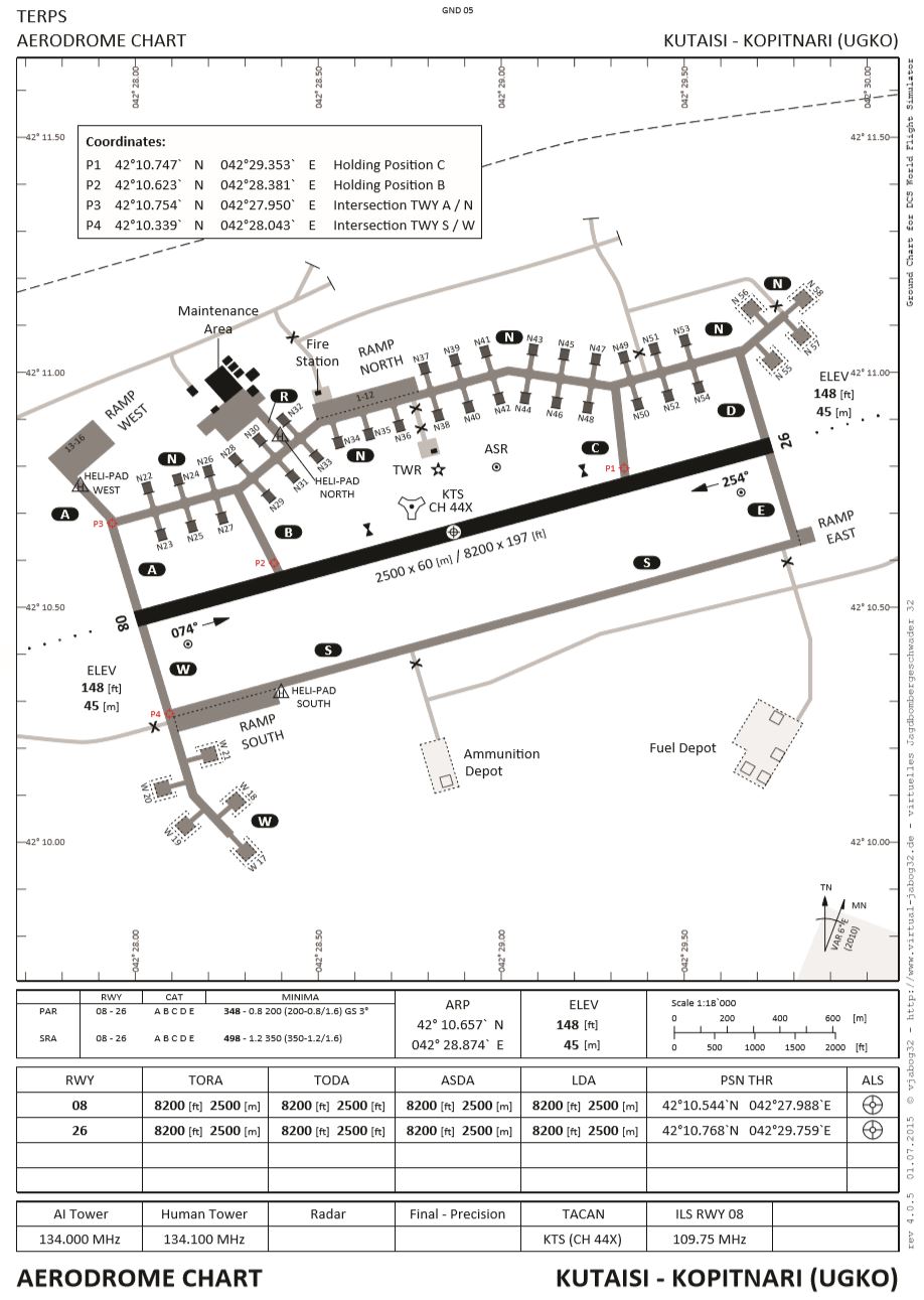
1.3. Kutaisi Taxiways
- During clearance, the runway to be used is announced.
The announcement is made in the form of the runway number, which is derived from the magnetic departure direction as a two-digit number of ten (080° -> 08).
In reality and also on some DCS multiplayer servers with human ATC, the exact taxi path to the runway is also given with the taxi clearance.Example:
- Our training airfield Kutaisi:
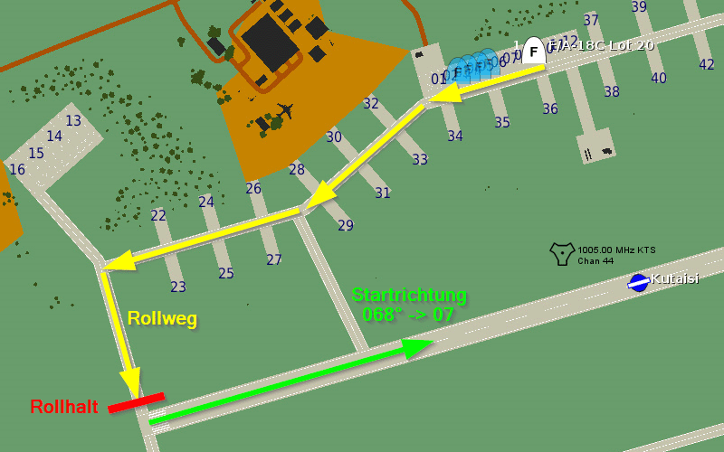
- Take-off position announced by ATC: 08.
- Check: Where do I have to hold to take off in direction 080?
- Which taxiways were explicitly given, or can I find my own way?
Usually you taxi parallel to the runway in the opposite direction until you reach the correct taxi hold at the end of the runway.
- Our training airfield Kutaisi: